By FREIDA FRISARO, TERRY SPENCER and DANIEL KOZIN
Associated Press
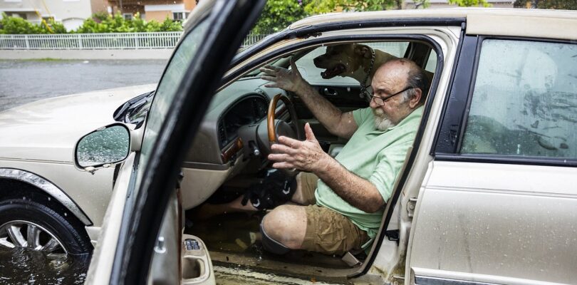
FORT LAUDERDALE, Fla. — A tropical disturbance that brought a rare flash flood emergency to much of southern Florida delayed flights at two of the state’s largest airports and left vehicles waterlogged and stalled in some of the region’s lowest lying streets.
“Looked like the beginning of a zombie movie,” said Ted Rico, a tow truck driver who spent much of Wednesday night and Thursday morning helping to clear the streets of stalled vehicles. “There’s cars littered everywhere, on top of sidewalks, in the median, in the middle of the street, no lights on. Just craziness, you know. Abandoned cars everywhere.”
Rico, of One Master Trucking Corp., was born and raised in Miami and said he was ready for the emergency.
“You know when its coming,” he said. “Every year it’s just getting worse and for some reason people just keep going through the puddles.”
Travelers across the area were trying to adjust their plans on Thursday morning. More than 20 inches (50 centimeters) of rain has fallen in some areas of South Florida since Tuesday, with more predicted over the next few days.
Ticket and security lines snaked around a domestic concourse at Fort Lauderdale-Hollywood International Airport just before noon Thursday. The travel boards showed about half of that terminal’s flights had been canceled or postponed.
Bill Carlisle, a Navy petty officer first class, had spent his morning trying to catch a flight back to Norfolk, Virginia. He had arrived at Miami International Airport at about 6:30 a.m., but 90 minutes later he was still in line and realized he couldn’t get his bags checked and through security in time to catch his flight.
“It was a zoo,” said Carlisle, a public affairs specialist. He was speaking for himself, not the Navy. “Nothing against the (airport) employees — there is only so much they can do.”
So he used his phone to book an afternoon flight out of Fort Lauderdale. He took a shuttle the 20 miles north, only to find that flight had been canceled. He was now heading back to Miami for a 9 p.m. flight, hoping it wouldn’t get canceled by the heavy rains expected later in the day. He was resigned, not angry.
“Just a long day sitting in airports,” Carlisle said. “This is kinda par for the course for government travel.”
Wednesday’s downpours and subsequent flooding blocked roads, floated vehicles and even delayed the Florida Panthers on their way to Stanley Cup games in Canada against the Edmonton Oilers.
The disorganized storm system was pushing across Florida from the Gulf of Mexico at roughly the same time as the early June start of hurricane season, which this year is forecast to be among the most active in recent memory amid concerns that climate change is increasing storm intensity.
The disturbance has not reached cyclone status and was given only a slight chance to form into a tropical system once it moves into the Atlantic Ocean after crossing Florida, according to the National Hurricane Center.
The National Weather Service in Miami noted in a post on the social media platform X early Thursday that a band of heavy rainfall was expected to fall over the region for a third day in a row.
“Even a small duration of heavy rainfall could lead to more flash flooding!” the post said.
Mayors in Fort Lauderdale and Hollywood declared a state of emergency for their cities on Wednesday afternoon. Later Wednesday, Florida Gov. Ron DeSantis also declared a state of emergency for five counties — Broward and Miami-Dade on Florida’s Atlantic coast and Collier, Lee and Sarasota counties on the state’s west coast.
Miami-Dade County Mayor Daniella Levine Cava also issued a local state of emergency.
Farther north, the National Weather Service in Melbourne confirmed that an EF-1 tornado hit Hobe Sound on Florida’s Atlantic Coast north of West Palm Beach on Wednesday morning.
The winds knocked down multiple banyan trees and caused some damage to a store, Martin County Fire Rescue officials said. No injuries were reported, but access to wealthy Jupiter Island was cut off by debris on the road.
It’s already been a wet and blustery week in Florida. In Miami, about 6 inches (15 centimeters) of rain fell Tuesday and 7 inches (17 centimeters) fell in Miami Beach, according to the National Weather Service. Hollywood got about 5 inches (12 centimeters).
More rain was forecast for the rest of the week, leading the weather service office in Miami to extend a flash flood watch through Thursday. Some places could see another 6 inches (15 centimeters) of rain.
The western side of the state, much of which has been in a prolonged drought, also got some major rainfall. Nearly 6.5 inches (16.5 centimeters) of rain fell Tuesday at Sarasota Bradenton International Airport, the weather service says, and flash flood warnings were in effect in those areas as well.
Forecasts predict an unusually busy hurricane season.
The National Oceanic and Atmospheric Administration estimates there is an 85% chance that the Atlantic hurricane season will be above average, predicting between 17 and 25 named storms in the coming months including up to 13 hurricanes and four major hurricanes. An average season has 14 named storms.


